Blog | 05 January 2024
Linking Risk and Science in Tropical Cyclone Seasonal & Multi-Annual Forecasting
The science of seasonal and multi-annual forecasting for tropical cyclones moves at breakneck speed - what are the main takeaways?


Catastrophe modelling provides a framework for translating scientific Tropical Cyclone information into risk and impact-based information. As the Tropical Cyclone (TC) science evolves, many novel questions emerge that can be explored by risk managers across the world. Given the speed at which new insight about TC’s arises in peer-reviewed literature, much of it may not be necessarily captured in the default set-up of TC cat models.
In particular, the research into forward-looking views of Tropical Cyclone activity (from seasonal to annual to decadal predictions) has been moving forward in leaps and bounds. Thanks to this progress, we’re able to start investigating risk-relevant questions such as:
In particular, the research into forward-looking views of Tropical Cyclone activity (from seasonal to annual to decadal predictions) has been moving forward in leaps and bounds. Thanks to this progress, we’re able to start investigating risk-relevant questions such as:
- What are reliable predictors of TC activity during different ENSO phases?
- What models might show skill at predicting not just basin-wide activity but also TC landfall?
- What are the new modelling techniques that insurers and cat modellers might be able to leverage?
As scientific papers are often difficult to digest for all but leading experts in the relevant fields of research, it is useful to investigate the recent findings. To this end, we share the digest from the recently published paper by Takaya et al: Recent Advances in Seasonal and Multi-annual tropical cyclone forecasting [1]. The focus of this blog is to share important points from 3 key areas: machine learning & basin-wide seasonal TC forecasting, seasonal predictions for TC landfall and multi-annual predictions.
My key takeaway from the review is that forward-looking views of TC risk are possible - but there are no quick wins. There is a winning strategy though: to develop a considered view of risk and keeping up-do-date with the latest science.
How is Machine Learning applied in TC Seasonal TC Forecasting?
The writing is on the wall: Machine Learning (ML) and Artificial Intelligence (AI) impact all fields of human ingenuity and TC forecasting is no exception. There are two main areas that can particularly benefit from machine learning:
The writing is on the wall: Machine Learning (ML) and Artificial Intelligence (AI) impact all fields of human ingenuity and TC forecasting is no exception. There are two main areas that can particularly benefit from machine learning:
- building new models for relevant parameters (eg. number of major TCs)
- mining existing databases for physical patterns that can then be used in TC modelling
For example, an ML-driven model can improve the skill of a model in predicting major hurricanes in the North Atlantic (NA) basin (Sun et al., 2021 [2]). It is these major hurricanes that are of the highest importance to reinsurance performance. Further, some research has shown that using neural networks can produce better predictions of ENSO than current dynamical forecasts and it can make skilful forecasts with long lead times - up to 1.5 years (Ham et al., 2019 [3] ). Increasing the lead times with ML-powered models was also shown for making predictions of Accumulated Cyclone Energy (ACE) in the NA basin (Asthana et al., 2021 [4]).
Machine Learning in Tropical Cyclone forecasting brings a lot of promise for the future, though it also comes with a pinch of salt. For example, model powered by Machine Learning need great amounts of data to produce good results and while simulated data is available, there is a limited amount of data on actual TC activity and might then present issues with overfitting.
One of the paper’s co-authors, Dr Nico Bruneau of Reask, explains this further: “ […] as a simple example, only 40-45 seasons (satellite-era) are available to train a model for TC activity prediction. With only 40 data points, there is a risk to select a large number of climate features as predictors, or even to find correlations with climate patterns that have very little links to TC dynamics. The outcome of such models would be highly questionable for decision making. Although back-testing would suggest good predictive skills, when deployed on real forecast data, such models are likely to have little predictive skills. Special attention and expert eyes need to play a key part in the model development to prevent such outcomes”.
One of the paper’s co-authors, Dr Nico Bruneau of Reask, explains this further: “ […] as a simple example, only 40-45 seasons (satellite-era) are available to train a model for TC activity prediction. With only 40 data points, there is a risk to select a large number of climate features as predictors, or even to find correlations with climate patterns that have very little links to TC dynamics. The outcome of such models would be highly questionable for decision making. Although back-testing would suggest good predictive skills, when deployed on real forecast data, such models are likely to have little predictive skills. Special attention and expert eyes need to play a key part in the model development to prevent such outcomes”.
Seasonal Predictions for TC Landfall
There’s evidence that models can provide skilful predictions of TC landfall in some regions and less so in others. For example, multiple models have shown significant skill in the Caribbean region, while the same cannot be said about other regions in the same basin (for example continental US). Therefore, products claiming to have skill at seasonal TC landfall in the US may need to be treated with some caution, as this claim is not yet supported by published peer-reviewed literature.
North Atlantic (NA) Basin
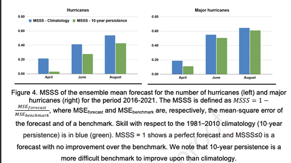
As one might expect, later initialisation dates (June onwards) tend to produce predictions that surpass climatological forecasts. For example, a model developed by the Geophysical Fluid Dynamics Laboratory (GDFL) for the Caribbean with a June start date surpassed climatological forecasts. With a July start date, the model not only surpassed climatological forecasts but also predicted the number of named storms, hurricanes and major hurricanes in the region. This suggests that information from this model could be considered in making risk-based decisions for this region after the start of the NA hurricane season.
Later initialisation dates tend to give better predictions than climatological forecasts also when an ensemble of models is considered (see figure below, extracted from Takaya et al., 2023 [1]). There’s a cautionary note though: while this seems to hold for the Caribbean, making predictions for some regions in the basin that are of most concern to the catastrophe risk industry, eg. continental US, has been more challenging.
Western North Pacific (WNP) Basin
For TC landfall models in the WNP, there is also strong regional variability in predictive power. In other words, TC landfall forecasting models show significant skill in some regions and less so in others. For example, a model used by the Guy Carpenter Asia-pacific Climate Impact Centre has shown to show some modest skill in predicting the total number of landfalling TCs in South China/Vietnam/Philippines region (when tested against 2016-2021 data, the models’ predictions were within two standard deviations from actual observations). But the same model shows less skill for making predictions in North-East Asia and East China.
Some regions of the WNP basin also show promise for longer-term landfall forecasting. A statistical model developed by Sparks and Toumi (2020 [5]) could potentially be used to predict landfalling TC’s in the region for 1-year prediction. A model with a such a long lead-time could inform the reinsurance strategies for the region.
Multi-annual predictions
Multi-annual predictions of TC activity in the NA basin have been made with some success. For example, a 5-year forecast uses an index that measures the relative difference between sea surface temperatures between MDR (Main Development Region) and the entire tropics [6] and predicts higher likelihood of increased TC activity in 2021-2025 in the NA basin. It is noted, however, that it has recently become challenging to predict the underlying Sea Surface Temperature (SST) index.
The Sea Surface Temperature in the NA basin shows various periods of cool and warm phases over multi-decadal periods. This phenomenon is now known as the Atlantic Multidecadal Variability (AMV). Many in the reinsurance industry will know this mode of variability as the Atlantic Multi-Decadal Oscillation (AMO), however in recent years science has called into question the oscillatory nature of this variability (e.g. Rousseau-Rizzi & Emanuel, 2022 [7]), and hence it has recently become more loosely known as the AMV.
It has been shown that AMV impacts TC activity over the tropical Atlantic and possibly also in the tropical Pacific. It appears that in different time periods and in different locations, there have been different drivers for AMV: from external forcings (including anthropogenic activity) through heat convergence to volcanic activity. This matters. The fact that the drivers of AMV are so varied means that it is extremely difficult to use it for projecting views of risk forward. Doing so could mix a great number of underlying signals, and these signals may well have different connections and predictive capability to TC activity. This is a critical factor in thinking through climate change trends and related risk-reporting for this region.
What next for Tropical Cyclone Forecasting?
Forward-looking views of TC risk are possible, and new techniques (along with more raw computational power) enable forecasters to make more skilful as well as longer-term predictions. Scientific and risk focused communities continue to answer more and more questions about TC activity, but many questions remain and many more arise. Some question marks surround the specifics of each model or how broadly it might be applicable. Other question marks open bigger topics: how do current catastrophe models account for near-term projections of climate change? What trends in TC activity can conclusively attributed to climate change?
At Maximum information, we’re actively looking for the answers. We invite you to follow us on LinkedIn, read the MaxInfo blog to find out more, and use MaxInfo’s completely free and open seasonal predictions model, developed during a collaboration between the Lighthill Risk Network, the London School of Economics, and two of the Takaya et al.’s (2023) co-authors, our own CEO Dr Tom Philp, and Reask’s Head of Research Dr Nicolas Bruneau.
References
[1] Yuhei Takaya, Louis-Philippe Caron, Eric Blake, François Bonnardot, Nicolas Bruneau, Joanne Camp, Johnny Chan, Paul Gregory, Jhordanne J. Jones, Namyoung Kang, Philip J. Klotzbach, Yuriy Kuleshov, Marie-Dominique Leroux, Julia F. Lockwood, Hiroyuki Murakami, Akio Nishimura, Dushmanta R. Pattanaik, Tom J. Philp, Yohan Ruprich-Robert, Ralf Toumi, Frédéric Vitart, Seonghee Won, Ruifen Zhan, Recent advances in seasonal and multi-annual tropical cyclone forecasting, Tropical Cyclone Research and Review, Volume 12, Issue 3, 2023
[2] Sun, Xia, et al. "A machine learning based ensemble forecasting optimization algorithm for preseason prediction of Atlantic hurricane activity." Atmosphere 12.4 (2021): 522.
[3] Ham, Yoo-Geun, Jeong-Hwan Kim, and Jing-Jia Luo. "Deep learning for multi-year ENSO forecasts." Nature 573.7775 (2019): 568-572.
[4] Asthana, Tanmay, et al. "Atlantic hurricane activity prediction: a machine learning approach." Atmosphere 12.4 (2021): 455.
[5] Sparks, Nathan, and Ralf Toumi. "Pacific subsurface ocean temperature as a long-range predictor of South China tropical cyclone landfall." Communications Earth & Environment 1.1 (2020): 30.
[6] the model was produced as part of collaboration between Willis Towers Watson and C3SvSectoral Applications of Decadal Predictions Project
[7] Rousseau-Rizzi, R., Emanuel, K. Natural and anthropogenic contributions to the hurricane drought of the 1970s–1980s. Nat Commun 13, 5074 (2022)